
 Asset Publisher
Polish forests
 fot. Paweł Fabijański
 fot. Paweł Fabijański
 fot. Paweł Fabijański
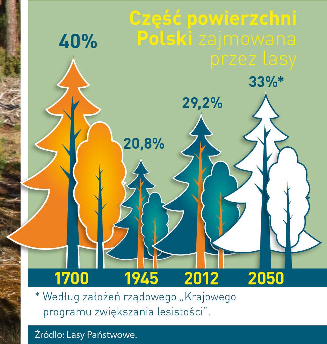
Poland is in the European lead, while concerning the area of all forests. They cover about 29,2 % of the country territory, and grow within the area of 9,1 million hectares. The overwhelming majority of the forests is state owned, of which almost 7,6 million hectares are managed by the State Forests National Forest Holding..
The number of Polish forest is still growing. The forestation rate of the country has increased from 21 % in 1945 to 29,2 % at the moment. Between 1995 and 2008, the forest area increased by 310 thousand ha. The basis for afforestation works is the "National Programme for Increasing the Forest Cover" (KPZL), assuming an increase of the forestation rate up to 30 % by 2020 and up to 33 % by 2050. Polish forests abound in flora, fauna and fungi. 65 % of the total number of animal species live there.
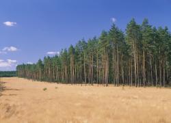
The forests grow in our country on poor soils, mainly because of the development of the agriculture in previous years. It influences the distribution of the types of the forest sites in Poland. Over 55 % of the forest areas is covered with coniferous forests. In other areas, there are forest sites, mainly the mixed ones. Their small part constitute alder and riparian forests – not more than 3 %.
In the years 1945 – 2011 the area of natural deciduous tree stands within the area of the State Forests National Forest Holding increased from 13 to 28,2 %.
Within the lowlands and uplands the most often occurring tee species is pine. It covers 64,3 % of the forest area of the State Forests National Forest Holding and 57,7 % of private and commune forests. In the mountains the predominant species is European spruce ( in the west) and European spruce with beech (in the east). Domination of pine is the result of carrying on sustainable forest management in the past. Once, the monocultures (crops or cultivations of one species) were the answer to the great demand of industry for wood. Such forests appeared to be quite fragile to climatic factors. They also were often the prey of pests' expansion.
In Polish forests, the share of other tree species, especially deciduous trees have been systematically increasing. The foresters have stepped aside from monocultures – that is why, they try to fit specific species of the forest stand to the natural stand, that would be proper for the given area. Thanks to that, in the years 1945 – 2011, the area of the deciduous tree stands within the lands of the State Forests National Forest Holding increased from 13 to 28,2 %. There occur more and more frequently the following tree species: oaks, ashes, maples, sycamore maples, elms, but also birches, beeches, alders, poplars, hornbeams, aspens, tilias and willows.
Our forests are the most often represented by the forest stands aged 40 to 80 years. The average age of the forest equals 60 years. More and more trees are of big size at the age over 80 years. Since the end of the Second World War, the forests' area has increased up to almost 1,85 million hectares.
Raport o stanie lasów w Polsce 2012
Asset Publisher
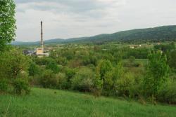
Nasze Lasy
Nasze Lasy
 Buczyna w leśnictwie Jawor fot. Marcin Plaza
 Buczyna w leśnictwie Jawor fot. Marcin Plaza
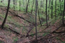
 Pasmo Żukowa fot. Marcin Plaza
Nadleśnictwo Ustrzyki Dolne zajmuje powierzchnię ponad 24 tys. ha. Podzielone jest na dwa obręby leśne - Brzegi i Stefkowa, w skład których wchodzi 17 leśnictw, w ramach których działa również ośrodek hodowli zwierzyny (OHZ).
Przynależność do krainy, dzielnicy przyrodniczo-leśnej i mezoregionów
Obszar nadleśnictwa Ustrzyki Dolne, według rejonizacji przyrodniczo-leśnej, położony jest w:
1. Krainie Karpackiej (VIII),
2. Dzielnicy Pogórza Środkowobeskidzkiego (VIII.2),
3. Mezoregionie Pogórza Przemyskiego (VIII.2.d),
4. Dzielnicy Bieszczadów (VIII.3),
5. Mezoregionie Bieszczadów (VIII.3.a).
Według podziału Polski na jednostki fizyczno–geograficzne (J. Kondracki 2002), omawiany teren leży w:
1. Obszarze: Europy Zachodniej,
2. Podobszarze: Karpat, Podkarpacia i Niziny Panońskiej(5),
3. Prowincji: Karpat Wschodnich (52),
4. Podprowincji: Beskidów Wschodnich (522),
5. Makroregionie: Beskidów Lesistych (522.1),
a. Mezoregionie: Gór Sanocko-Turczańskich (522.11),
b. Mezoregionie: Bieszczadów Zachodnich (522.12).
Położenie geograficzne i wysokościowe
Obszar terytorialnego zasięgu działania nadleśnictwa leży między 24o23' a 24o43' długości geograficznej wschodniej oraz między 49o18' a 49o36' szerokości geograficznej północnej. Wysokość nad poziom morza zawiera się w granicach od 320 do 910 m.
Rzeźba terenu
Obszar nadleśnictwa jest urozmaicony, obejmując szereg pasm górskich przebiegających z reguły w kierunku NW - SE. Lasy leżą w silnie urzeźbionym terenie, zajmując przeważnie najwyższe wzniesienia, a w terenach niższych najbardziej strome stoki. Wszystkie kompleksy leśne poprzecinane są licznymi potokami i jarami o różnym stopniu nachylenia i różnej wystawie. Najwyższe wzniesienia n.p.m. omawianego terenu to: Jaworniki – 910 m; Żuków – 876 m; Kamienna Laworta – 769 m; Halicz – 762 m; Jawor – 742 m; Jasień – 734 m; Wielki Król – 726 m; Brancowa – 685 m; Stożek – 683 m; Truszowskie – 675 m; Kiczera – 632 m; Magura – 630 m; Przysłup – 549 m.
Warunki klimatyczne
Teren Nadleśnictwa Ustrzyki Dolne (wg Romera 1949) leży w strefie klimatów górskich i podgórskich - typ klimatu górskiego, w tym w dwóch podtypach:
– podtypie górskim,
– podtypie kotlin śródgórskich.
Klimat omawianego obszaru charakteryzuje się bogatymi opadami, zmienną temperaturą powietrza w zależności od wysokości n.p.m., krótkim okresem wegetacji, długim okresem występowania przymrozków oraz występowaniem silnych wiatrów. Przeważają wiatry zachodnie, południowe i południowo-wschodnie. Średnie sumaryczne opady roczne wynoszą ok. 800 mm. Najwięcej opadów notuje się w okresie wegetacji, w miesiącach letnich. Średnia temperatura powietrza spada o około 0,5 °C na każde 100 metrów wzniesienia. Średnia roczna temperatura wynosi 8°C. Średnia temperatura okresu wegetacyjnego wynosi 15°C. Okres wegetacyjny trwa 5 do 6 miesięcy. Przymrozki późne występują do końca maja, a wczesne od połowy września. Pokrywa śnieżna zalega od października do kwietnia, jej grubość dochodzi często do 1 metra, a miejscami do 2 metrów.
Warunki wodne
Nadleśnictwo Ustrzyki Dolne leży w zlewniach dwóch mórz:
– Morza Czarnego (cała zlewnia rzeki Strwiąż),
– Morza Bałtyckiego (cała zlewnia rzeki San).
W zlewni Morza Czarnego leży większość lasów obrębu Brzegi Dolne oraz północno-wschodnia część lasów obrębu Stefkowa (oddz.: 1-5; 15-17;24; 107-112; 139; 140). W zlewni Morza Bałtyckiego leżą lasy położone na południowych stokach pasma Żuków oraz w kompleksach Stożki i Daszówka (leśnictwo Łobozew i Teleśnica) obrębu Brzegi Dolne oraz większa część lasów obrębu Stefkowa (poza wymienionymi wyżej oddziałami).
Warunki glebowe
Dominują gleby brunatne wyługowane (69,79%), rzadziej występują gleby brunatne właściwe (16,56%) i brunatne kwaśne (12,74%). Następnymi pod względem zajmowanej powierzchni typami gleb są mady i gleby rdzawe. Pozostałe typy gleb: rankery, gruntowoglejowe, opadowoglejowe, torfowe mają niewielki udział. Gleby brunatne występują na stokach o ułatwionym odpływie wód powierzchniowych, płowe - głównie na płaszczyznach zrównań wierzchowinowych, zaś mady i gleby mułowe i glejowe - w dolinach rzek i potoków. Na wymienionych glebach wytworzyły się bardzo żyzne siedliska leśne.